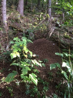
 | Day 1 - H-Ant hill = Ant Colony Mapping - 28.09.15 On the 1st day, we went to the forest and found Ant hills. Every group had their own area and in our area we found three ant hills. We label each one with a sticker and took a pictures of them. Day 2 - Data Collection - 05.10.15 On the 2nd day, we went back to one of our 3 ant hill and investigate on it, and see if the ant hill is active or not, and we also used three specimen jars to collect three ants as samples. location Longitude: 6°59'59" Location Latitude: 46°20'23" Name of our colony: Mars Canopy cover: 80% Green ground cover: 50% Ants activity level: 8 Guiding Questions 1) Why is it important to map the location of the ants? - It’s important to map the location of the ants, because mapping the location would help us find where exactly the mound is, for the next time we go back and see the mound and to actually know where it is on a map (google map/earth). 2) Given what you’ve seen of the ants, what factors may be interesting to study? - Some interesting factors that we may want to study could be how the ant travels from and to their mound. Another could be how they gather food etc. 3) What characteristics of the mounds or the ants did you notice as you recorded their location? - There were not so many of them. It is probably because it was cold outside and it was morning. So ants were probably inside. |
 RSS Feed
